|
Vincent Pica
Chief of Staff, First District, Southern Region (D1SR)
United States Coast Guard Auxiliary
|
|
Your TV and EPIRB went digital – or Did They?
Back in 2006, we wrote about the value and use of the Emergency Radio Position Indicating Beacon – EPIRB (see SSP, “EPIRBs, PPIRBs GPIRBs – What?” 11/29/06). The article was all about how price was coming down so survivability was going up. The key now is whether someone will hear you. On 1/28/09, we wrote that your TV and EPIRB were going digital (see SSP, “Your TV Has Gone Digital - So Has Your EPIRB!” 1/28/09.) But did they…? This column is about that. TV Delayed Till June
The original deadline for conversion of all US TVs to digital reception was February 17, 2009. That date was set almost a decade ago. However survey company Nielsen Co estimated that over six million households are still without digital cutover boxes. Those affected are mostly poor and rural households who do not have cable or satellite subscriptions. So, the Congress voted to delay the conversion until June 12, 2009. Sounds trivial – except that it will cost the taxpayers over $650mm in delayed revenues. But, with that said, we’re in this together…
What’s with the EPIRBs then?
True to form and the schedule, on February 1, 2009, the satellite rescue system maintained by COSPAS-SARSAT on a global basis simply stopped listening to the 121.5 MHz EPIRB signal. This was a great day for rescue teams. As you saw here on 1/28/09, “…the number of false alerts with digital beacons is significantly lower than analog beacons. The digital nature allows the satellite’s technology to distinguish between a radio beacon and some other transmitter on the same frequency. In the analog days, only about one in five alerts actually ended up coming from a beacon – rather than from ATMs, pizza ovens and stadium scoreboards. This high rate of false alarms lowered responsiveness (“cry wolf” effect), took resources away from real emergencies (since crews had to be dispatched to find out if the alarm was real or not), was very expensive and put the lives of responders at risk needlessly. Can you imagine what the fire department would do if 80% of the in-coming fire alarms were false…?”
So, what’s the beef? At times, plenty – and you need to be aware when, where and how…
|
No Digital Position? No Digital Positioning!
Well, unless your EPIRB is a “GPIRB” (see SSP, “EPIRBs, PPIRBs GPIRBs – What?” 11/29/06) or has been tied into your on-board GPS, it can’t send the digital coordinates of where you are. It sends the same analog signal as the 121.5 MHz devices did for triangulation by ground personnel and technology. Yup. That’s the deal.
|
 |
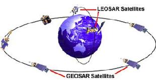
| image provided courtesy of COSPAS-SARSAT |
|
|
What is different is this. If you look at the diagram of the COSPAS-SARSAT satellite system, you’ll see two different types. There are those in low Earth rotations – LEOSAR satellites (around +/-525 miles above the Earth (yeah, that’s low)) and those that are in very high altitudes and as such are “geo-stationary” – GEOSAR satellites (about 40x’s higher – 22,000 miles above the surface orbiting at the same speed as the Earth so they appear to be stationary.) As you might figure, the LEOSARs just can’t see as much of the Earth’s surface at the GEOSARs do. But the 121.5 MHz device signals couldn’t make it 22,000 miles to the GEOSARs – but the 406 devices can. And from 22,000 miles up, you can see just about everything on Earth but the Polar Regions. From 70o North to 70o South, those GEOSARs will see you, or rather “hear” you, when your EPIRB sends a signal. So far, so good. But if the GEOSARs don’t see the digital GPS location, they do exactly – nothing! The LEOSARs take over and, while the 406 MHz signal gives the LEOSARs a much more precise fix (3 miles vs 12 miles), there is no digital position embedded in the signal so the LEOSARs, working with one or more of the Local User Terminals around the world (operated by governments and their Search and Rescue arms), use very complex mathematics and “Doppler Shift” technology to figure out where you are (or were, by the time the data gets to SAR forces – bear in mind that it could take 40 minutes for the processing and analysis to get to somebody relevant.)
So, hook your EPIRB into your boats GPS and you’re good to go. Right? Well, yes, as long as you don’t actually have to go – as in abandoning ship. Then, you unhook the EPIRB from your GPS and take it with you. Your GPS, and its digital positioning data, go to the bottom and you go in the rescue pod or dinghy. You just went from digital to analog…
As you read here in that 11/26/06 article, prices keep coming down and GPIRBs are certainly the most expensive versions. As CPO Mario Vittone, ASTC USCG, pointed out in a column that he wrote, inspiring this one, here’s the math:
- 406 EPRIBS are four times more accurate than the 121.5 EPIRBS were.
- 406 EPIRBS with on board GPS are two-hundred times more accurate.
The cost differential is but $100-$200. Worth your life, Bunky?
|
BTW, if you are interested in being part of USCG Forces, email me at JoinUSCGAux@aol.com or go direct to the D1SR Human Resources department, who are in charge of new members matters, at DSO-HR and we will help you “get in this thing…”
|
| <-- click there to tweet, post or otherwise distribute to the 'net
|
|